

Provided by Beth Gilhespy, author of the Walking Through Time series of books on geology of the Niagara Escarpment. All photos and diagrams in this post are from Walking Through Time: Geology of the Beaver Valley 2nd Edition, 2026.
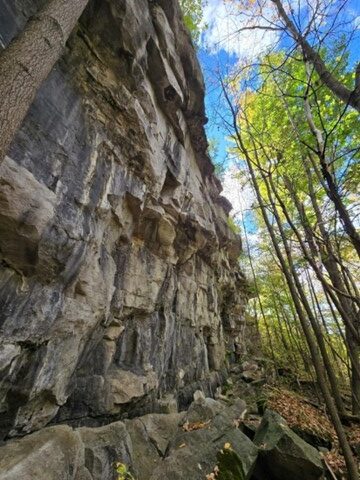
[Amabel Dolostone cliffs dominate the heights of the Beaver Valley at Old Baldy, Metcalf Rock and Eagle’s Summit (shown here). Photo by Beth Gilhespy.]
The Beaver Valley is, at heart, a story written in stone.
Its cliffs, waterfalls, rolling fields and forested slopes are the visible expression of a sequence of sedimentary rocks laid down between about 450 and 428 million years ago in a warm, shallow tropical sea that once covered southern Ontario. Those layers, deposited in the Michigan Basin, now form part of the great arc of the Niagara Escarpment.
OVERVIEW
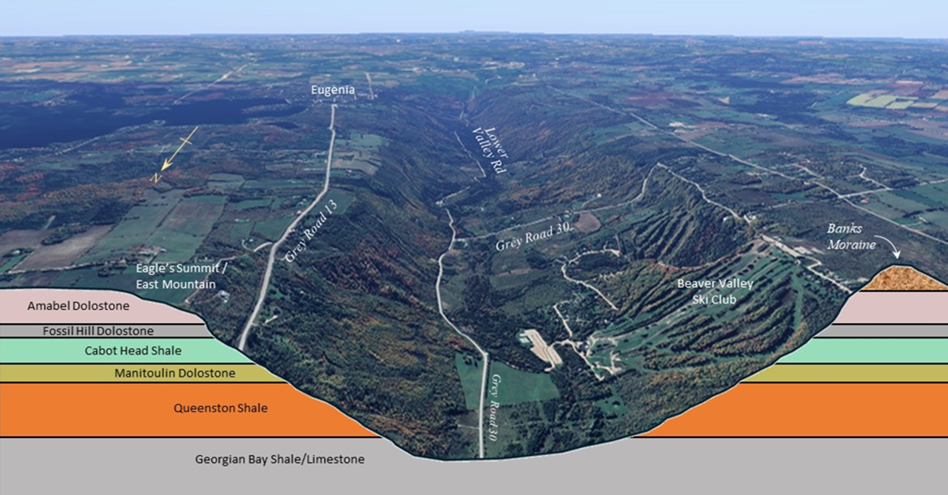
[Cross section of the Beaver Valley looking south from the Kimberley area, showing Niagara Escarpment bedrock layers.]
1. QUEENSTON SHALE
At the base of the escarpment lies the Queenston Shale, a thick, brick-red layer of iron-rich mud deposited in the late Ordovician Period. In the Beaver Valley, this shale is unusually prominent. Because the region sits atop the gently uplifted Algonquin Arch, nearly the full thickness of the Queenston Shale rises high above Georgian Bay, forming the broad, convex lower slopes seen at Loree Forest and along the Beaver River. Though often cloaked in vegetation, its soft nature underpins the valley’s agricultural fields and contributes to the escarpment’s dramatic profile through long-term undercutting and erosion.
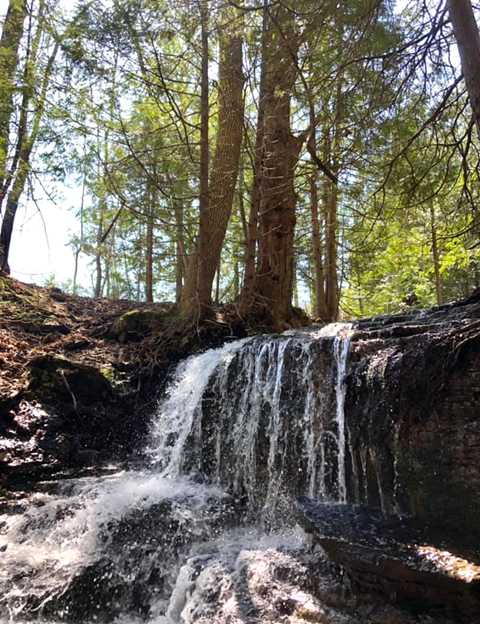
2. MANITOULIN DOLOSTONE
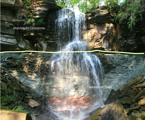
[At an unnamed creek below Pinnacle Rock, water flows over the thin layers of Manitoulin Dolostone to reach a steep drop over a plunge pool formed in the Queenston Shale. Photo by Lilla Fodor.]
Resting directly above the shale is the Manitoulin Dolostone, a thinly bedded, grey reef rock formed as tropical seas cleared and coral communities flourished in the early Silurian. This layer marks the boundary between the Ordovician and Silurian periods, a time of mass extinction and gradual biological recovery.
In the Beaver Valley, the Manitoulin Dolostone forms flat terraces, secondary ledges, and the lips of many waterfalls, including Webwood and Hogg’s Falls. Fossils of brachiopods, crinoids and rugose corals are preserved within it, reminders of the ancient sea that once shimmered overhead.
[The boundary between the Queenston Shale (late Ordovician in age) and Manitoulin Dolostone (early Silurian in age) at the Beaver Valley’s Webwood Falls near Fairmount marks a time when 60 percent of all life on earth went extinct. Photo by Brian Popelier]
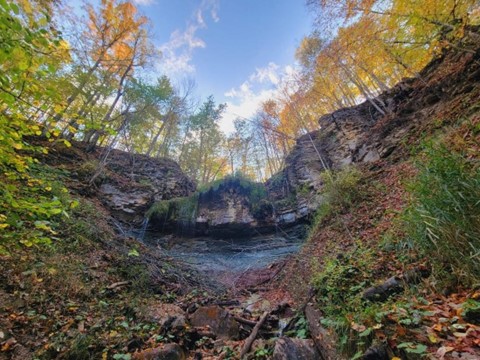
[A delightful waterfall exists on the Bruce Trail’s Stew Hilts Side Trail near Vandaleur, where water first flows over a cliff of Manitoulin Dolostone to fall on the soft Queenston Shale below. Photo by Annette Sandberg.]
3. CABOT HEAD SHALE
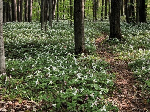
[Just north of Metcalf Rock, trilliums carpet the forest floor of Cabot Head Shale in mid May. Photo by Lilla Fodor.]
Above the Manitoulin Dolostone lies the Cabot Head Shale, a softer mix of red and green-grey shale deposited in nearshore, muddy conditions. Though rarely exposed, it plays a crucial hydrological role.
As groundwater percolates through the overlying dolostone and meets this impermeable shale, it is forced sideways, emerging as springs along the escarpment slopes. Many of the valley’s clear, cold seeps trace this subtle boundary.
4. FOSSIL HILL DOLOSTONE and
5. AMABEL DOLOSTONE
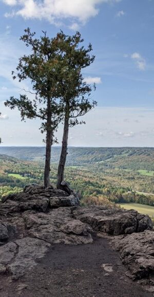
[The view from the Amabel Dolostone eights at Old Baldy, high above the village of Kimberley. Photo by Bo Penny.]
Capping these layers is the Fossil Hill Dolostone and, above it, the magnificent Amabel Dolostone caprock. The Fossil Hill layer contains corals and stromatoporoids (extinct sea sponges), whose silica contributed to the formation of chert used by Indigenous peoples for toolmaking after the glaciers retreated.
The overlying Amabel Dolostone, thickly bedded and resistant, forms the bold cliffs of Old Baldy, Metcalfe Rock and Eagle’s Nest. Built from reef mounds that grew upward toward sunlight as the basin slowly subsided, this layer is the escarpment’s defining crown.
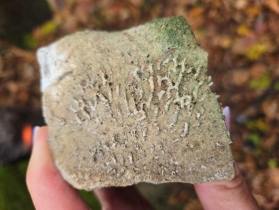
[Syringopora (organ pipe coral), dating from about 430 million years ago, is one of the many fossil corals found in Beaver Valley rock. Photo by Beth Gilhespy.]
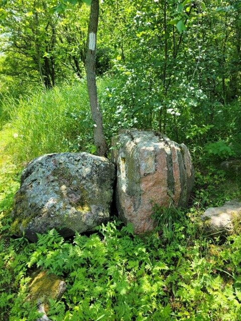
GLACIERS CARVED THIS BEDROCK
[Photo by Beth Gilhespy.]
Yet the Beaver Valley landscape we see today is far younger than its bedrock. About 12,000 years ago, retreating glaciers released torrents of meltwater that carved the V-shaped valley at right angles to the escarpment face. The modern Beaver and Boyne Rivers are modest heirs to that cataclysmic flow.
Glacial debris, including igneous and metamorphic erratics carried to the area from the Canadian Shield, as well as the sweeping Banks and Gibraltar moraines, records the ice’s final pauses across the region, before the glacier retreated about 12,000 years ago.
Thousands of years later, European settlers to the area moved these boulders to the field edges as they cleared the land for farming.
WATER STILL LEAVES ITS MARK
[This small flowerpot at Indian Brook was carved by wave action during high lake levels about 5,000 years ago.] (Source: Walking Through Time: Geology of the Beaver Valley 2nd Edition, 2026)
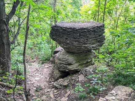
Water has continued its quiet work since. High post-glacial lake levels sculpted wave-cut features and flowerpots along dolostone ledges. Chemical weathering dissolved carbonate rock to create karst features and sinkholes at Wodehouse, while freeze-thaw cycles widened cracks into crevices and caves (see below).
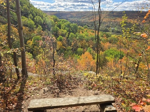
To walk the Beaver Valley is to walk through time: from tropical reef to glacial torrent to living landscape. Its geology is not static stone, but a dynamic interplay of deposition, uplift, erosion and renewal. It is an ancient foundation beneath a continually changing, vibrant world.
ADDITIONAL DIAGRAMS
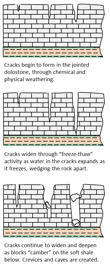
Throughout the Beaver Valley, explorers can find numerous deep crevices in the Niagara Escarpment bedrock, including at Old Baldy, Duncan Escarpment and Metcalf Rock.
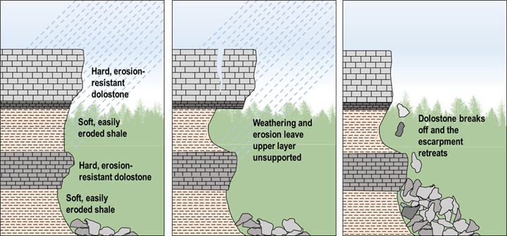
The Niagara Escarpment cliff face has been retreating due to the impact of weathering and erosion (Source: Walking Through Time: Geology of the Beaver Valley 2nd Edition, 2026, modified from www.cgenarchive.org/toronto-niagara-escarpment.html)
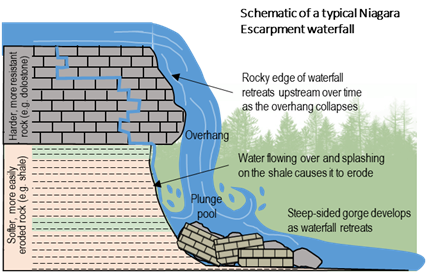
The Beaver Valley is home to several sparkling waterfalls that spill over the rock layers as the water makes its way down the slopes into the valley, carving gorges and creating intriguing geological features. Waterfalls develop when water flows over a harder, more resistant rock (e.g. dolostone) overlying softer, more easily eroded rock (e.g. shale). Water erodes the softer rock which creates an overhang. This unsupported rock will eventually collapse, causing the waterfall to retreat upstream. A steep-sided river valley is created as the waterfall retreats.
Related posts:
 E. C. Carr Observatory
 Growing a Resilient Future Using Local Seeds
 Late Winter/Early Spring birds
 Ramping Up for Spring
 Citizen Scientists Monitor Plant Sales and Trails for Invasive Species
 Old Baldy Does Not Exist
 John Muir: Early Years in the Beaver Valley Area
 Osprey Historic Walking Tour
 Glaciers, Habitat, and Old River Postcards
 Keep Our Skies Dark